Do models transfer? Irrigation mapping with satellite embeddings
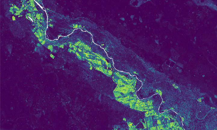 Irrigation probability around Chokwe, 2021, from TESSERA embeddings
| At a glance | |
|---|---|
| Where | Chokwe, Xai-Xai, Manica and Catandica, Mozambique (my PhD sites) |
| When | 2026, presented at the WaterNet symposium in Arusha |
| Data | Sentinel-2 annual geomedian, AlphaEarth and TESSERA embeddings, field data from 2021 |
| Method | Random forest, trained on one site and applied to the others |
| Status | Work in progress: one year (2021), one random seed |
In my PhD, irrigation models trained in one part of Mozambique did not work well in another. Geospatial foundation models like AlphaEarth (Google DeepMind) and TESSERA (Cambridge) are pretrained on satellite data from all over the world, so I wanted to know if models built on them transfer better.
The random forest is always trained on my own field data. The only difference is the input per pixel: 12 Sentinel-2 bands and indices, or 64 (AlphaEarth) or 128 (TESSERA) embedding values.
The maps
Choose a site, the input data and where the model was trained. “Own data” means trained and applied on the same site. The rest are transfers. Yellow is a high probability of irrigation, dark purple a low one.
Some to compare:
- Catandica, trained on Chokwe. TESSERA still finds the irrigated valleys, AlphaEarth makes most of the map uncertain, and Sentinel-2 loses most of the pattern.
- Chokwe, trained on Catandica, with AlphaEarth. The irrigation scheme is still the brightest area, but it stays below 50%, so in a class map it is gone.
- Manica, trained on the other three sites. Both embeddings come close to the map from Manica’s own data. Sentinel-2 doesn’t.
Results so far
On their own site all three work well, with an irrigation F1 of 0.92 or higher. After a transfer:
- TESSERA had the best irrigation F1 in 14 of the 16 site-to-site transfers. Median F1 was 0.70 for TESSERA, 0.39 for AlphaEarth and 0.28 for Sentinel-2.
- With AlphaEarth the irrigated area after a transfer ranged from about 1% to 26 times the area of its own map. The class maps still look clean, so you can’t see from the map that it went wrong.
- Sentinel-2 did not transfer well, also not when I trained on the other three sites together. That is the same as in my PhD.
- With the embeddings, the irrigated fields often still have the highest probability after a transfer, but below the 0.5 threshold. A few local field points to set a new threshold could fix a lot of that. I haven’t tested this yet.
Related: Mapping smallholder irrigation in Mozambique · Uncharted territory: my PhD · WaterNet 2026 talk